



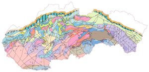
Tectonic Map of the Tertiary Bedrock of the Inner Western Carpathians, Fusán, O. et al., 1987, scale 1:500,000
The tectonic map of the Tertiary basement of the Inner Western Carpathians at a scale of 1: 500,000 depicts the exposure of the fundamental tectonic units from the Pre-Upper Cretaceous period, when the nappe structure was formed. The map shows the distribution of tectonic units at the surface and an interpretation of their continuation beneath the Cenozoic (Paleogene, Neogene, and Quaternary) sedimentary and volcanogenic formations overlying the tectonic units. The interpretation of the structure is based on geophysical data and boreholes that reached pre-Tertiary formations in the bedrock, or on boreholes that were important for interpretation but did not reach the bedrock. Also depicted in the bedrock is a network of faults, thrusts, and nappe boundaries – some identified from surface features and others inferred from geophysical measurements and boreholes. The Tertiary bedrock of the Inner Western Carpathians is interpreted as the Pieniny cliff zone, which separates the Inner and Outer Western Carpathians (according to A. Biely’s classification). In the outer (flysch) belt, the thickness of the sedimentary rock layers – primarily of Tertiary age – is so great that even today there is not a single borehole in Slovakia that has reached the bedrock beneath the flysch layers. Geophysical measurements allow only indirect interpretations of the tectonic structure and lithological composition of the pre-Tertiary bedrock in the outer Western Carpathians; therefore, the map does not show the outer zone. Interpretation of the buried Pre-Tertiary basement in basins and depressions is a fundamental prerequisite for the exploration of new mineral resources and geothermal energy sources in deep geological structures.