



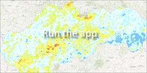
 The web application documents the state of contamination of the territory of Slovakia with the radioisotope cesium (137Cs) in relation to the reference date 1. 1. 2005. When creating the maps, all available measurement results from the entire territory of the Slovak Republic for the period 1990-2003 were used.
The spatial distribution of values is significantly differentiated in our territory:
🟢 Lowest contamination (below 500 Bq/m²)
The lowest activities are concentrated in the east, in the central part of the south and in the west of Slovakia in the wider area of the Váh and Nitra basins. These are mainly the areas:
-
East Slovak Lowland
-
Košice basin
-
Slanské vrchy
🟡 Increased contamination (over 3,000 Bq/m²)
Increased values were recorded in a band about 40 km wide in the direction northwest – southeast, which covers:
-
High and Low Tatras
-
Štiavnické vrchy and Pohronský Inovec
-
The Danube Mountains and the Danube Plain (wider surroundings of Galanta and Dunajská Streda)
🔴 Highest measured values
Three areas with the absolute highest activity (137Cs) in Slovakia were located within the aforementioned northwest-southeast zone:
-
Nový Tekov – 28,684 Bq/m²
-
Košuty – 23,054 Bq/m²
-
Banská Štiavnica – 18,077 Bq/m²
📅 About the application
Application launch: 04/2009