



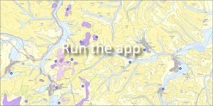
 Authors: Elečko, M., Vass, D., Konečný, V., Gaálová, K., Gaál, Ľ. | Scale: 1 : 50,000 | Year of publication: 2001
This map was published as the first map of the new edition Geological and educational maps of Slovakia. It provides a professional interpretation of the geological structure of the area and at the same time brings valuable information about natural values, tourist attractions and important localities of the region.
🌋 Geographical and geological context
The Cerová Highlands are located in southern Slovakia in the Banská Bystrica Self-Governing Region (districts Lučenec and Rimavská Sobota). The mountain range has an elongated shape in the west-east direction and is among our most important volcanic mountain ranges.
🏰 Important sites and European rarities
The Cerová vrchovina Protected Landscape Area (declared in 1989) extends over the mountain range, which protects unique volcanic forms and relief. The most important points include:
-
Šomoška National Park (proclaimed in 1954): World-famous castle hill with a unique Stone Waterfall. This exceptional geological phenomenon was created by the columnar cleavage of basalt into regular pentagonal and hexagonal prisms and is one of the European natural rarities.
-
PP Pohanský hrad: A natural monument with the occurrence of stone seas and specific volcanic forms.
-
Hajnáčka: The ruins of a Gothic castle from the 14th century, which is situated directly on a steep rocky hill of volcanic origin.
📋 Information about the edition:
-
Focus: Connecting the geological development of the area with its rich history and cultural heritage for the needs of geotourism.
Useful links:
👉 [ Basic features of the geological structure of the Cerova Highlands (PDF) ]
👉 [ Basic information about the wildlife of the Cerova Highlands (PDF) ]
📅 About the application
Application launch: 03/2013