



 Author: Marsina, K. et al. | Year of publication: 1999
The web application presents the results of comprehensive geochemical mapping, which forms the basic pillar for understanding the Slovak landscape. The quantitative chemical composition of the main rock types represents basic geochemical information, without which it is not possible to objectively assess the quality and distribution of chemical elements in other components of the environment, especially in waters, soils and sediments.
🔬 Scope of research and lithotypes
-
Data base: The research processed data from almost 4,000 mostly newly collected rock samples.
-
Classification: In the territory of Slovakia, 64 main lithotypes (rock types) were distinguished.
-
Statistical outputs: The atlas offers detailed text explanations and statistical files with basic mathematical and statistical parameters of the main components and 26 secondary elements.
🎨 Meaning of colors on the map: Buffering capacity of rocks
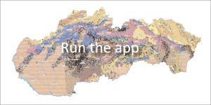
The spatial distribution of lithotypes is shown on the map at a scale of 1:1,000,000. The color scheme of the map was designed to directly express the buffering capacity of rocks (the ability to neutralize acidic environments):
-
🟦 🟩 Blue and green colors: Represent carbonate and basic rocks with high buffering capacity.
-
🟥 🟧 Red and orange colors: Indicate more acidic rocks.
-
🟨 Light yellow color: Indicates rocks with a predominance of quartz and low buffering capacity.
📖 Ccitation of work:
MARSINA, K. et al.: Geochemical Atlas of the Slovak Republic, Part III: Rocks [online]. Bratislava: Dionýz Štúr State Geological Institute, 1999. Available at: https://app.geology.sk/atlashorniny.
📅 About the application
Application launch: 06/2017