



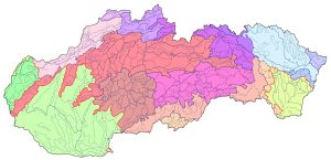
Geomorphological Division of Slovakia, Mazúr, E. and Lukniš, M. 1986, scale 1:500,000
The analog maps by Mazúr and Lukniš depicting the geomorphological division of Slovakia are among the most significant works in Slovak geography. They are the work of two prominent classical, field-based synthetic geographers. The authors drew upon Hromádek’s orographic classification (1956), as well as a map of relief types (Mazúr 1975), geological maps at a scale of 1:200,000, a map of the morphostructures of the Western Carpathians, and, above all, their own findings from fieldwork. The classification of their geomorphological division underwent some evolution, and the digital map shown here is based on the more recent edition from 1986 (Mazúr, E., Lukniš, M., 1986: Geomorphological Division of the SSR and ČSSR. Slovakia Section. Slovak Cartography, Bratislava). The territory of Slovakia is hierarchically subdivided into 499 individual geomorphological units across 8 levels: system, subsystem, province, subprovince, region, unit, subunit, and part. Slovakia is part of the Alpine-Himalayan system; its territory is divided into two subsystems – the Carpathians and the Pannonian Basin – which are further subdivided into the Western and Eastern Carpathians, and the West Pannonian and East Pannonian Basins, respectively. A more detailed breakdown can be found on the map.