



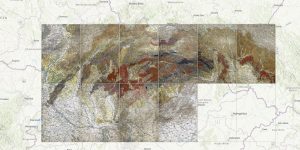
A unique edition of maps in M 1:200,000, apparently completely unknown to the geological community, was compiled probably immediately after the establishment of the State Geological Institute of the Czechoslovak Republic.
This is a collection of 10 separate sheets covering almost the entire territory of the Slovak Republic. The peculiarity is that, despite the assignment of an inventory number, there is no surviving document for the maps. The only available information is information on the Tectonic map of the Western Carpathians of central Slovakia on the Banská Bystrica sheet. When compared with the geological map, it is clear at first glance that it is a map compiled by the same authors.
The tectonic map was compiled by A. Matějko and D. Andrusov using several map sources by R. Ketner, O. Kodym, J. Koutek, V. Šťastný and V. Zoubek and was published in 1922. The publisher was the Military Geographical Institute and the topographical sources were used lists of the Military General 1:200,000.
This map was also published as one of the many appendices of the Excursion Guide to the Western Carpathians organized on the occasion of the 3rd meeting of the Association for the Development of Carpathian Geology in Czechoslovakia in 1931. The editors of the guide published in French were A. Matějka and D. Andrusov.