



After the establishment of the Czechoslovak Republic in 1918, geological research in our territory was transferred to the competence of the State Geological Institute of the Czechoslovak Republic in Prague. Its main content was detailed geological mapping and research of the territory of Czechoslovakia.
On the initiative of Czech geologists, extensive basic geological research began on the territory of Slovakia. The initiators of these works were R. Kettner, J. Koutek, V. Zoubek, A. Matějka, O. Kodym, D. Andrusov and others.
In 1931, a congress of the Carpathian Geological Association took place in Slovakia, during which field trips were organized. The text guide to the excursions provided a new synthesis of the geological structure of the Western Carpathians and changed the view of their development.
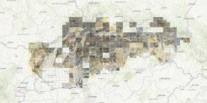
In 1940, after the establishment of the independent Slovak Republic, the State Geological Institute was established in Bratislava, which followed up on these investigations. Under the leadership of D. Andrusov, the next stage of geological mapping of Slovakia began. Compilation of detailed maps on a scale of 1:25 and 75,000 continued even after World War II. This edition of maps contributed significantly to clarifying the geological structure of some parts of our territory. In the presented mosaic of map originals, the given maps are presented together for the first time.