



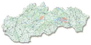
Inorganic soil contamination is expressed by the intersection of the sets of contents of risk elements exceeding the threshold values. It was compiled from the mono-element geochemical maps made by application of geostatistical methods based on the results of 5,189 chemical analyses of forest and agricultural soils. The density of soil sampling was 1 sample per 10 square kilometres in average. Point and diffuse soil contamination according to the limits in force (Decision of the Ministry of Agriculture of the SR No. 531/1994-540) is represented on the map. The extent of the areas with relatively clean soils and the areas with higher background concentration of elements in soil is obvious. The spreading of the limit exceeding contents of risk elements is related to the geochemical, but above all anthropogenically produced, contamination sources in the areas of old mining, processing and metallurgical factories (Central Slovakia and the Spiš-Gemer area). It also indicates the transfer of contaminants into the alluvial zones of rivers and brooks.