



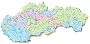
Principal Hydrogeological Regions, Malík, P. and Švasta, J., scale 1 : 1,000,000, Atlas of the Slovak Republic, 2002
Principal hydrogeological regions, shown on the map, respond to the distribution of main water balancing units – “hydrogeological rayons” – delineated by Šuba et al. (1995). These are depicted, using different colours, according to the dominating rock permeability type in the regions: intergranular (porous), fissure or karst-fissure types. Number of the hydrogeological region, shown on the map, is linked to the “hydrogeological rayon identifier”, as maintained, balanced and reported from the groundwater usage point of view by the Slovak Hydrometeorological Institute.