



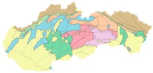
Regional Geological Division of Slovakia, Vass, D. et al., 1998, scale 1 : 500,000
In the late 1970s, the need arose for a regional geological classification of the Czechoslovak Western Carpathians. This need arose from the emerging databases associated with intensifying regional geological research and the program to create geological maps of the regions at a scale of 1:50,000. In compiling this classification, the principles used to develop the regional geological division of the Bohemian Massif were broadly followed. The map of the regional geological division of the Western Carpathians and the northern extensions of the Pannonian Basin defines units of three orders, from the largest to the smallest. In some areas, fourth-order units have also been identified, typically representing complexes of Pre-Tertiary bedrock surrounded by younger rocks. The units of the regional geological classification are compared with those of the regional geomorphological classification (Mazúr & Lukniš, 1978; 1980, and Czudek et al., 1972). They are similar across most of the territory, but differ in some areas, such as in basins and depressions or in the units of the Inner Carpathian Paleogene. A more detailed classification can be found on the map.