



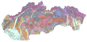
Map of Engineering-Geological Zones, Liščák, P., 2017, scale 1:50,000
The map depicts territorial units delineated based on the consistency of occurrence of certain lithological rock types within individual genetic-facial complexes exposed at the surface of the territory. The map depicts 50 different engineering-geological zones of Pre-Quaternary and Quaternary rocks. Since the base map used is the 1:50,000 Digital geological map of the Slovak Republic, which generally depicts Quaternary rocks thicker than 5 m (or, in some cases, Quaternary rocks of lesser thickness but which are exceptional in terms of their genesis – dead-arm sediments, peatlands, and anthropogenic fill – Quaternary regions are depicted over a significantly smaller area than they actually cover. The map also includes legend tables containing the symbol and name of the engineering-geological region and the name of the lithological-genetic formation.