



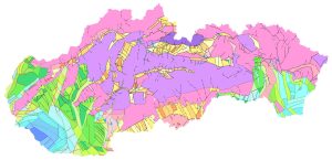
Neotektonická mapa Slovenska, Maglay, J. a kol., 1999, scale 1 : 500,000
For the first time, it presents a comprehensive qualitative and areal assessment of the most recent cycle of tectonic activity in the Western Carpathians and the Pannonian Basin within Slovakia. It illustrates the resulting structuralization of tectonic activity during this cycle of geodynamic evolution. It records the relative dynamics of vertical movements of individual block structures-distinguishable at this scale – it depicts their current state and the resulting probable movement trends for forecasting the subsequent development of tectonic activity in the next geological period. Given that, compared to earlier geological periods, the Quaternary is extremely short and, moreover, is represented in Slovakia exclusively by continental developments, the situation depicted on the map is not limited solely to the Quaternary period but captures movements over a time span extending to the last 3.5 million years, thereby also accounting for the dynamics of the Upper Pliocene. Another reason for extending the period of tectonic evolution under study is the often problematic distinction in practice between Upper Pliocene and Lower Pleistocene sediments, due to a gradual sedimentary transition in subsiding areas, or the corresponding continuous tectonic evolution at the Pliocene – Quaternary boundary. Furthermore, when evaluating the data for map creation, the Pliocene period was considered the initial phase of geodynamic evolution in the Quaternary.